Stem the floods – don’t hold back rewilding
Rewilding could make a big difference but sluggish policy-making is slowing us down says Dr Steve Carver
Published 08/09/2016
Something troubled me on the BBC Today programme this morning. The show’s North of England correspondent was talking about the government’s report on last December’s floods. From his perspective, locals who have suffered so much feel that “No amount of money will stop this flooding from repeating.” He added, “The future is about personal resilience. What are people going to do in their houses?” He mentioned the use of “stainless steel kitchen units” that can be “hosed down” after a flood.
What concerned me was a perhaps understandable note of resignation. And right now, as the nights draw in, people don’t want another government report, they a want solution.
I believe that rewilding, as part of a broad-based and progressive approach, could be such a solution. That said, the scientific evidence on the benefits of rewilding is sparse. This is largely because rewilding is relatively new. What we do have, however, is a growing body of data that relates to how human activities and land management impact natural processes.
Fewer sheep, more trees…
I’m no hydrologist, but having studied as an undergraduate at Huddersfield back in the early 1980s I have a pretty good working knowledge. I learnt, for instance, that sheep grazing compacts the soil and reduces infiltration capacity, thus increasing surface runoff in rainfall events. Woodland on the same soils has the opposite effect.
More recent long-term experimental work by the Centre for Ecology and Hydrology (CEH) and Imperial College at Pontbren in Wales has reinforced these results, showing that removing sheep grazing and planting trees increases infiltration capacities by as much as 67 times and reduces surface runoff by as much as 78% [1]. Surely, this must help alleviate downstream flooding pressures?
Rewilding aside, we need to look carefully not just at the terrain, climate, soils, vegetation, etc. and the hydrological processes that determine river flows and flood events, but also at the complex interplay of social, cultural, political and economic factors that govern land use, management, ownership, revenue and people. In particular, we need to concern ourselves with the politics of power and responsibility.
Vested interests
There are powerful vested interests in maintaining the status quo in the British uplands. While these people are happy to accept agricultural and environmental subsidies, they remain almost wholly focused on the production of food and fibre and management of the land for “sporting” activities, often at a financial loss if it wasn’t for subsidies . Much of this management takes place with very little regard for what goes on downstream as regards flood protection.
Almost all environmental service delivery is based on a “what’s in it for us?” or “what little can we get away with?” attitude. Aldo Leopold sums it up perfectly: “When the private landowner is asked to perform some unprofitable act for the good of the community, he today assents only with outstretched palm. If the act costs him cash this is fair and proper, but when it costs only forethought, open-mindedness, or time, the issue is at least debatable” [2].
Climate change and increasing intensity of rainfall means that the return periods of large flood events are getting shorter [3]. As yesterday’s “unprecedented” becomes tomorrow’s “normal”, we are likely to see more floods like those that hit northern Britain over the 2015 Christmas period and the flooding of the Somerset Levels in 2014. The personal misery and costs to the individual are hard to calculate and, I am sure, even harder to bear, but what is clear is that as flood frequencies and levels increase, some quite radical measures will need to be taken to alleviate the problem.
This doesn’t simply mean pouring more concrete and building ever-higher flood defences to protect beleaguered downstream communities. Nor does it imply having to dredge channels to increase flood water throughput. Instead, we must take a long hard look at upstream land use and management practices.
The causes of flooding
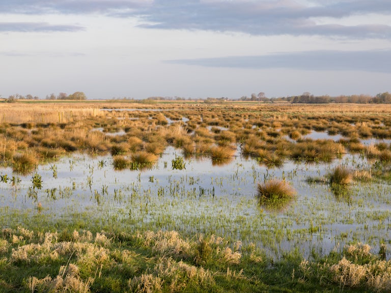
Heavy and prolonged rainfall, especially onto already saturated ground, is the principal cause of flooding, but how we manage the land upstream of flood-prone areas can have a significant effect. Land drainage, deforestation, overgrazing, bare ground and channelisation of rivers together with increasing urbanisation and associated impervious surfaces have combined to exacerbate the flood problem. Even flood defences can make flooding worse in unprotected areas immediately up and downstream of farms and communities. This is because they can back up in front of constrictions created by hard flood defences or rush flood waters on downstream.
Grants for upland drainage in the 60s and 70s aimed at improving grazing were snapped up by many land owners. Look at an aerial image on Google maps of the Pennines and other peat moorlands and you’ll often see a dense herring-bone pattern of linear ditches or “grips” criss-crossing the hills. These have lowered the water table – drying out the peat, changing heather to grass – and increased drainage density. This has the combined effect of significantly increasing the speed that rain can run off the land and into our rivers, reducing lag times and potentially increasing the “flashiness” of the river and thus its propensity to flood [4].
While there is contradictory evidence as to the exact effects of grips on floods, it seems likely that overall they can only make matters worse. In a peculiar turn of fortune, grants are now available for blocking the very grips the same land owners dug, but now with the aim of reducing drainage densities and rewetting the moors .
Grouse moor management
Grouse moor management and especially “muirburn” [5] is detrimental to water quality, wildlife and dissolved organic carbon , but can muirburn really increase runoff?
When done badly, especially when adjacent to drainage channels/streams, the answer is almost certainly “yes” because it increases the amount of bare peat. This leads to increased surface runoff, although there is a lack of detailed evidence to prove this conclusively. Nevertheless, Hebden Bridge, which was hit hard by flooding on Boxing Day 2015, is downstream of the Walshaw Moor Estate. This is the grouse moor at the centre of a prosecution case brought by Natural England against the moor’s owner for allegedly digging unauthorised drainage channels and excessive burning of heather on blanket bog.
Certainly, grouse moor management is not beneficial to flooding, even if shooting interest groups try to make out otherwise. The Moorland Association and the Heather Trust have only recently realised they need to do something to mitigate the worst effects of their activities and improve their public image with events such as “bogathon” aimed at improving the water retention capacity of their members’ moors. Many of these moors would have been mixed woodland in the past and would revert to woodland again if not managed specifically to maximise the surplus population of grouse for shooting.
Aside from driven grouse shooting and deer stalking in Scotland, sheep grazing is the dominant activity in most of upland Britain. Intensive grazing with domestic livestock has two effects on hydrology: reducing and simplifying vegetation cover to a close-cropped grass sward by grazing, and compacting thin mineral soils through trampling. The former reduces interception storage and surface roughness, as well as reducing biodiversity, while the latter reduces infiltration capacity through compaction and increases surface runoff [6]. During prolonged periods of heavy rainfall, there is precious little to hold the water in the hills, resulting in increased downstream flood risk .
The flooding of the Somerset Levels during early 2014 resulted from heavy and prolonged rainfall, made worse by questionable land management practices. Farming maize and potato crops in the catchment increases the area of bare soil in the winter months which, because it is compacted by mechanisation, reduces infiltration capacity. Increased surface runoff and soil erosion are the result. This is especially true on steeper slopes near to water courses where the eroded soils end up being deposited in Rivers Parrett and Tone, reducing their capacity and further exacerbating the flooding problem [7]. Nutrients leaching directly from bare fields into river courses also encourage in-channel weed growth which reduces flow velocities and traps more sediment, further reducing cross-sectional area, leading to calls to dredge the affected rivers [8].
Addressing effects, not causes
Engineering solutions rarely treat the cause. Rather, they attempt to address the effects. Demands from flooded farmers and residents to dredge rivers to help maintain their capacity and transfer flood waters downstream are a knee-jerk reaction to the threat of flooding. For dredging to be effective it needs to be carried out along the whole length of the main river, which is costly in terms of both money and riverine habitats and ecology.
While local dredging may be effective in reducing flooding in the immediate vicinity, and is desirable in a few instances, it only speeds the flood waters on to multiply the flooding downstream . In addition, sediment in the river channel comes from erosion of soils, hillsides and river banks upstream, but why so much that it causes problems from choked river channels downstream?
Clearly, we wouldn’t have to dredge if the sediment supply was reduced by ensuring better vegetation cover (again, more trees) protecting vulnerable soils, hillsides and river banks from overgrazing (yet again, fewer sheep). Similarly, there is a limit to just how high we can build flood defences to protect farmland and urban areas on the flood plain. Like dredging, pouring concrete is also expensive and, while a very visible form of flood defence to local residents whose homes and businesses are at risk, it is not the answer.
Money thrown at building extra flood defences after high-profile flooding is just a response aimed at saving political face. Ultimately, engineered flood defences will always fail in the face of increased rainfall intensity and shortening return periods as we cannot afford to keep on building them higher and higher.
Natural flood management
A few recent projects have begun to address the flood problem at source with natural flood management (NFM) techniques. Slowing the Flow and other similar projects show how changes to upstream land use, insertion of large woody debris (LWD) dams in streams, increased surface storage, etc. can slow runoff by increasing lag times and attenuating flow peaks and so reduce soil erosion and increase sediment trapping. All of which can reduce downstream flooding and benefit habitats and wildlife. It can also be achieved without costly and intrusive engineering works .
River restoration projects can also allow flood plains to store flood waters and increase the length and roughness from the source to the mouth of the river, so reducing its overall gradient, slowing flows and increasing flood response times.
River restoration employs NFM approaches together with “soft engineering” such as reinstating meanders, re-profiling banks, increasing floodplain woodland/scrub, creating floodplain mires, etc.
In essence, rivers flood periodically and overflowing onto wooded floodplains is nature’s way of coping with flood waters. Giving back a river’s freedom on its floodplain through river restoration might mean allowing farmland to flood, but surely this is better than the alternative of flooded homes and businesses? Free-ranging rivers in unconstrained flood plains have shown how we can increase resilience of catchments to flood events.
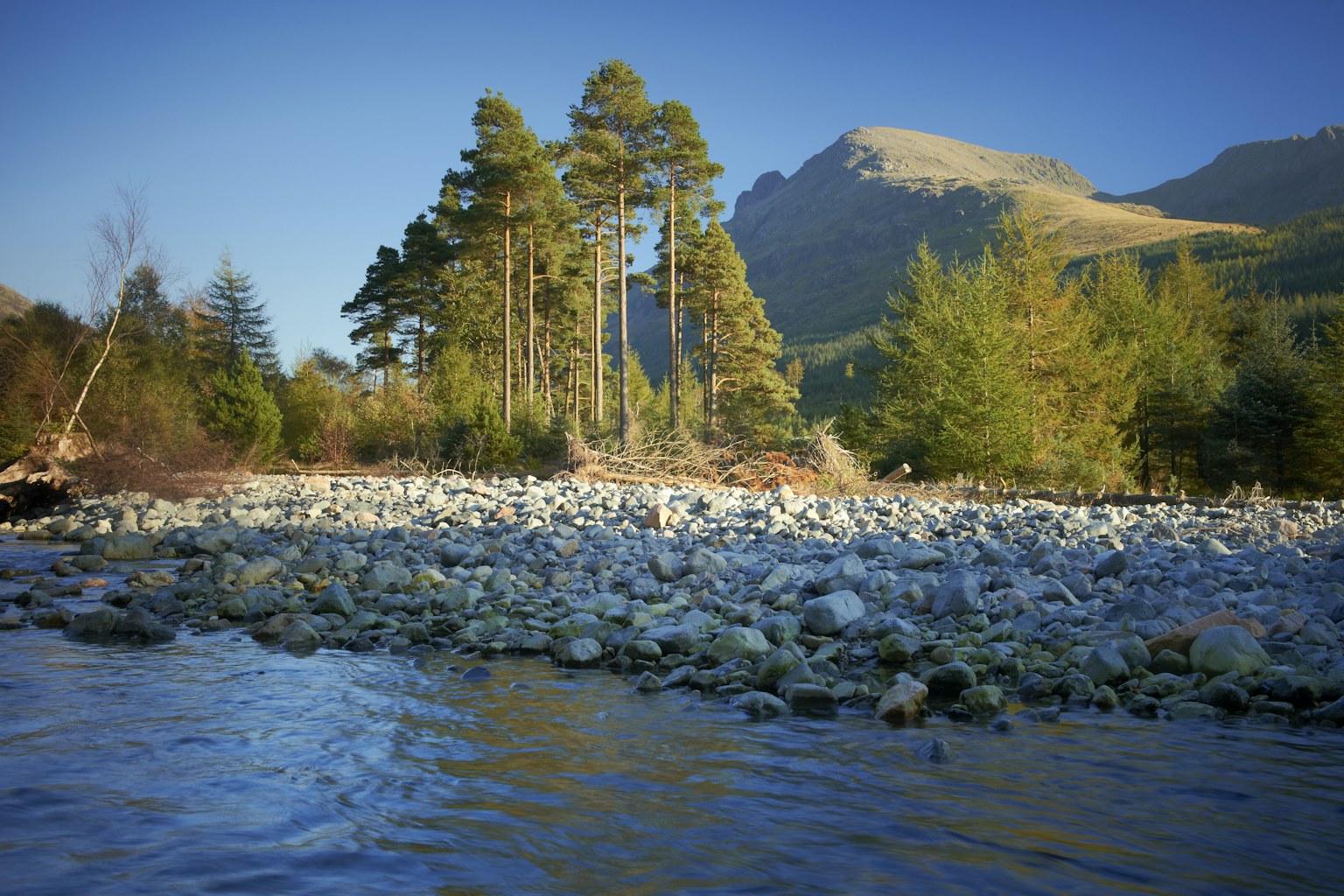
A good example here is the River Liza in Ennerdale, Cumbria. In both the 2009 and 2015 floods, the river responded to the heavy rainfall by escaping the confines of its banks and onto its floodplain. This is what natural floodplains are for. But while the river overflowed, the floodplain absorbed the extra water and energy but also effectively “filtered” the flood waters of its sediment load before discharging into Ennerdale Water. This had the effect of both attenuating the flood peak and reducing its sediment load.
While other rivers in adjacent valleys all flooded and lakes in the region all witnessed massive increases in turbidity, Ennerdale remained clear and flooding downstream was minimal. The difference is reasonably attributable to differences between Ennerdale and other Lake District rivers. Not only is the River Liza in Ennerdale free to move around its floodplain, the fell sides in the valley are subject to less grazing and have considerably more trees than their neighbours wherein bare, sheep-grazed hillsides and channelised rivers are more the norm [9].
Beavers do it for free
At the recent Upland Hydrology conference in Leeds I sat through a day of talks and discussions about NFM projects. All were about human-engineered NFM approaches which try to mimic the effects of natural in-stream LWD dams and wetlands in limiting downstream flooding. There was no mention of beavers until I brought them up in the final Q&A session.
We face an establishment who hold it in their power to do something positive about the flooding problem and yet the desire to remain in control prevents a simple measure that could do much of what is needed essentially for free. This has led to calls for beaver reintroductions in order to realise the benefits for flooding, water quality, habitats and biodiversity. While there are some local concerns associated with localised flooding, experience from abroad shows that they can be safely managed and land owners appropriately compensated.
Is rewilding really the answer?
If fewer sheep, more trees, restoring rivers to their floodplains and reintroducing beavers can be considered rewilding, then the answer to the above question is yes.
A fully coordinated and integrated policy through the full course of the river can ensure maximum benefits at minimum cost and risk. This includes mapping of the spatial configuration of contributing areas and flood alleviation measures, since slowing the flow at one point may exacerbate the problem by delaying its flood peak to coincide with a flood peak coming downstream from higher in the catchment.
Just as hard-engineered flood defences alone don’t cut it, then neither will soft-engineered or NFM techniques used in isolation. We still need hard flood defences to protect towns and cities at critical points on the floodplain. Integrated catchment management is the way forward, and distributed rewilding to address the problem at source and intercept and slow flood waters along the course of the river must be part of this mix.
The flood-response-review cycle needs to be broken and the sticking plaster approach replaced with a radical overhaul of how we plan for, manage and minimise the impacts of flooding. And crucially, combined NFM and rewilding approaches may be far cheaper in the long run than traditional hard-engineered approaches.
Who pays?
This will be foremost in the minds of land owners who are being asked to modify their activities in the uplands and the farmers whose most productive floodplain fields might be flooded to save homes and businesses in downstream urban areas.
Where the costs are borne by the few in areas remote from the many who benefit, it is likely that land owners and rural farmers will bear the brunt of land use and policy changes. Paying land owners up and down the catchment to do the right thing might be one way forward. This should be through public funding for activities including grip blocking, rewetting, cutting heather instead of burning, woodland regeneration, reduced grazing pressure, insertion of LWD dams (or better still beaver reintroductions so they can do it for us), river restoration, creating wash lands and wetlands and allowing farmland to flood.
As the NFU representative and county advisor at the Upland Hydrology conference said “We’ll do anything you like… as long as you pay us for it”.
The economist, Dieter Helm attacks this question head on and calls for a small flood levy, paid either through our water bills or insurance which when multiplied across the whole UK population represents a huge sum of cash. How this is actually spent is open for debate, but it should not be used to pay land owners for flood-sensitive land use management practices while they continue to receive monies for practices that exacerbate the flood problem.
The other radical change required is to bring all the communities involved together in a catchment-wide planning exercise to plan and decide how to address the flooding problem, how to adapt existing policies, and how to increase resilience and accountability throughout the social thalweg.
This is an updated and abridged version of an article from issue 37 of ECOS magazine
published by the British Association of Nature Conservationists. Dr Steve Carver is director of the Wildland Research Institute at the School of Geography, University of Leeds
[1] Marshall, M. R., et al. (2014) “The impact of rural land management changes on soil hydraulic properties and runoff processes: results from experimental plots in upland UK.” Hydrological Processes 28.4: 2617-2629.
[2] Aldo Leopold (1949) A Sand County Almanac. OUP, p.250.
[3] Chan, S. C., et al. “Projected increases in summer and winter UK sub-daily precipitation extremes from high-resolution regional climate models.” Environmental Research Letters 9.8 (2014): 084019.
[4] Holden, J. et al. (2004) “Artificial drainage of peatlands: hydrological and hydrochemical process and wetland restoration.” Progress in Physical Geography 28.1: 95-123 and Lane, S. et al. (2013) “Impacts of upland open drains upon runoff generation: a numerical assessment of catchment scale impacts.” Hydrological Processes 27.12: 1701-1726.
[5] Burning of heather to create a patchwork mosaic of different ages for the benefit of grouse.
[6] Marshall, M. R., et al. (2014) "The impact of rural land management changes on soil hydraulic properties and runoff processes: results from experimental plots in upland UK." Hydrological Processes 28.4: 2617-2629.
[7] Palmer, R. and Smith, R. (2013) "Soil structural degradation in SW England and its impact on surface water runoff generation." Soil Use and Management 29.4: 567-575.
[8] Clarke, Stewart J. (2002) "Vegetation growth in rivers: influences upon sediment and nutrient dynamics." Progress in Physical Geography 26.2: 159-172.
[9] Why Wild Ennerdale is then increasing cattle grazing on the floodplain is open for debate. Perhaps it is to “farm” the HLS payments for the extra headage, or perhaps it can be seen as a sop to local farming interests who see the rewilding of Ennerdale as a threat to farming in the Lake District? Whatever the reason, there is surely a conflict between flood protection afforded by a wild river and floodplain woodland and the suppression of woodland regeneration and bank erosion that may result from the extra cattle.