Revealing rewilding's true impact
Research Scientist Dr Sahran Higgins reports on our progress towards creating a unique framework to monitor rewilding.

Published 06/08/2025
Rewilding Britain has been collaborating with technological experts and rewilding sites across Britain on state-of-the-art monitoring techniques that hope to reveal the full picture of rewilding’s impact on nature and, eventually, our communities. Research Scientist Dr Sahran Higgins shares some of her highlights so far.
On a recent visit to the wonderful Knepp Estate, I was struck by how visceral the experience was, from the electrifying call of the ironically named ‘common’ nightingale that greeted me to the feeling of being enveloped by the trees and shrubs that seemingly open up in front of you, only to close up again as you pass. Young oaks peeked out through a tangle of blackthorn and hawthorn and, high in the treetops, bill-clattering white storks greeted each other as they returned to the nest. The place is messy, wonderful and wild.
As a scientist, I’m fascinated by how we measure this wildness. How can we quantify these tangible changes in rewilding landscapes – and the surrounding community – brought about by the innovative interventions of rewilding practitioners across Britain?
“The data and visualisations from monitoring can reveal hidden patterns and stories in the landscape, bringing to light natural wonders that have always been there, but just haven’t been visible to us.”
Sahran Higgins
Research Scientist
Building an evidence base
That’s exactly the question we’re trying to answer here at Rewilding Britain through the Rewilding Monitoring Framework. We’re so lucky to work with and learn from hundreds of rewilders within the Rewilding Network. They’re keen to undertake monitoring to help inform their rewilding journey and track progress, but they also tell us that it’s time-consuming and expensive to monitor changes in a consistent way.
In designing the Framework for and, critically, with the Network as well a host of other experts across academia, the public sector and environmental NGOs, we want to make things easier. What makes it unique is that it will set out recommendations for monitoring not only ecological change over time, but measuring the capacity for rewilding to deliver social and economic benefits to local communities. Being able to demonstrate these developments is essential in understanding rewilding’s full impact and in building the evidence around it as a viable land use option.
As we embark on the project’s second phase, which focuses on socio-economic monitoring, I want to share some of the insights – and surprises – from the first part of our journey, during which we’ve been working with technological experts to put the Framework’s ecological aspects through its paces on rewilding sites across Britain.

Piloting out in the field
The great thing about rewilders is they’re quite often ‘first movers’, up for trying something a bit different to the norm. So it came as no surprise that when we approached Rewilding Network members to help us pilot the ecological metrics of the Framework, they were keen. This community holds huge amounts of knowledge in their combined heads, not only about the ecological and social impacts of their projects, but about what’s practical and which areas need more thought.
Five projects were selected based on a variety of factors, including how long they’ve been rewilding, whether the land is upland or lowland, the type of ownership model and previous land use. The result was a great section of rewilding sites across Britain: Wild Woodbury, Dorset; Hepple Wilds, Northumberland; Pentwyn, Radnorshire; Carrifran, Scotland; and Heal Somerset.
The purpose of the pilot stage was two-fold. Firstly, to sense check the range of indicators suggested: how easy was the data to collect, what level of resource was needed and how interpretable was it? Secondly, to assess how well (or not) the suggested indicators scaled up: can a survey method on a 40-hectare site work equally as well on a 20,000+ hectare site, and what are the technical or logistical challenges?
As well as testing the best ways of gathering biodiversity data (for example, diversity and numbers of species), we also set out to trial innovative ways of measuring whether rewilding is increasing ‘ecological complexity’ at a site [1]. In other words, are sites undergoing rewilding helping reinstate ecosystem processes, such as disturbance (e.g. natural grazing by animals), complexity (e.g. of vegetation structure and food webs) and dispersal (e.g. of movement of species through landscape)? Is the natural regeneration of vegetation and the behaviour of herds of grazing herbivores such as wild ponies or longhorn cattle actually bringing about an ever-changing mosaic of habitats?
Join the Rewilding Network
Be at the forefront of the rewilding movement. Learn, grow, connect.

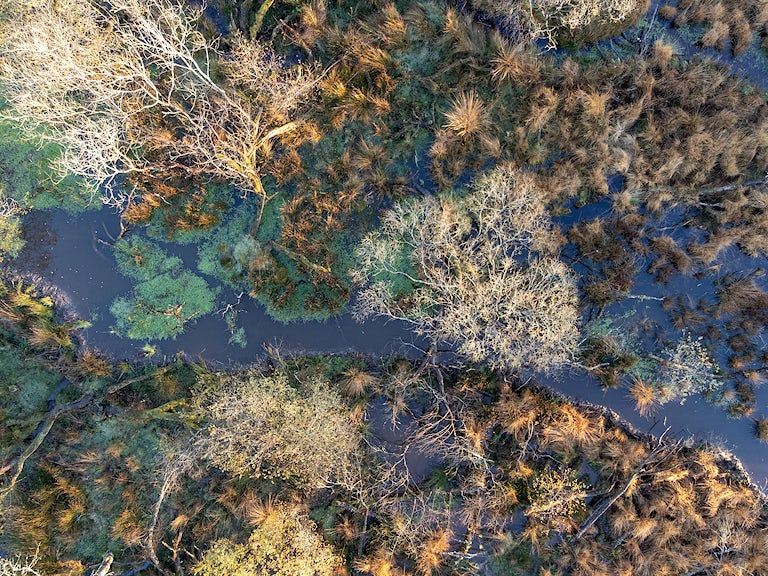
Eye in the sky technology
To help us test this at the pilot sites we teamed up with experts at Queen Mary University of London (QMUL), part of the Framework advisory group, to apply a remote sensing approach using LiDAR sensors mounted on drones. This ‘eye in the sky’ approach is ideal for the type of large-scale monitoring that rewilding requires. By using LiDAR (which stands for Light Detection and Ranging) we can show changes in vegetation structure at the landscape scale, for example, the expansion of new vegetation through natural regeneration over time.
Specialists at the university were able to combine historic LiDAR datasets from the Environment Agency and new datasets from their own drones – through a lot of geospatial analysis wizardry! – to look at changes in vegetation height and extent over an average three-year period. Despite this relatively short time frame in rewilding terms (the most significant changes from rewilding can often take decades to become apparent), results from the pilot projects showed that all sites have seen an expansion over the last few years of tall perennials, scrub and mature trees – and a decrease in ground and short grass.

Why is that significant?, you might ask. It matters because changes in vegetation structure are influenced by the ecological processes taking place in a given area and they in turn affect biodiversity, by shaping where a species lives, what it eats, how it interacts with other species [2]. Essentially, diversity in vegetation heights and densities can influence other aspects of nature’s recovery in a given area. Although still early days, this technique has also allowed us to quantify the diverse range of new vegetation at these different projects and further demonstrates the huge value of having a baseline, or a point in time before rewilding began, to compare change to.
On top of this, because LiDAR can measure ‘above ground biomass’ (i.e., the mass of the total living vegetation above the soil, so stems, branches and leaves), it’s a useful indicator of how much carbon a site can potentially sequester and store [3]. This could, in time, support rewilding projects to access carbon credit markets in the future. This is something that Knepp has been exploring thanks to funding for their Wildland Carbon Project from our Rewilding Innovation Fund.
An ear to the ground
One of the reasons I’m endlessly intrigued by rewilding is because it’s so full of surprises. Earlier this year, we were exploring the findings from the acoustic monitoring we supported pilot projects to trial with help from the British Trust for Ornithology (BTO) and I was astonished by the sounds that the hazel dormouse makes! By recording in ultrasonic we were able to capture a recording of the tiny creature (Muscardinus avellanarius).Having been processed by the BTO to bring it into human hearing range, we were amazed to hear that the call sounded like a shrill whistling kettle!

BTO worked with the pilot projects to collect both bioacoustic data (i.e. the sounds made by animals) and ecoacoustic data, or soundscapes, that can provide information on behaviour, distribution and interactions. Passive acoustic monitoring such as this is becoming increasingly popular for monitoring bird, bat and small mammal populations in rewilding sites, particularly as it can be left to record unattended, programmed to collect data at key times of the day and night specific to different species.
Soundscapes is an emerging area of interest and early studies have shown promise in their ability to extract ecological information from all sounds at a landscape scale [4]. Animals can emit sounds in all sorts of ways; the stridulations of bush-crickets, the call of deer, frog vocalisations in ponds. Similarly to other remote monitoring approaches, such as remote sensing, bioacoustic monitoring allows for continuous monitoring and can reveal the presence of species that perhaps were unknown before. This can be hugely insightful when thinking about shy, nocturnal or returning species and where they fit into the food chain (think predators!).
Birds, bats and bush crickets
“Passive acoustic monitoring shines in its ability to detect multiple species groups over long periods – without needing an expert in the field,” explains BTO researcher Adham Ashton-Butt. Recorders were deployed across 500 m² grids at rewilding sites, running day and night for up to four months across spring and summer 2024. They captured audible sounds (birds) by day and ultrasonic calls (bats, small mammals, bush-crickets) by night, covering a wide range of species.
Recordings were processed using the BTO Acoustic Pipeline, with machine-learning classifiers identifying species, followed by expert verification. The results were striking: 80 bird species recorded at Hepple in Northumberland and 15 of the UK’s 18 bat species detected at Heal Somerset. A standout find was the number of hazel dormouse detections. An elusive, nocturnal species that’s typically hard to monitor, acoustics revealed its presence with ease.
Adham and his colleague Stuart Newson (developer of the bat and mammal classifiers) hope that developments at the BTO will soon allow rewilding projects to track a wider range of species, from beavers to wild boar – while continuing to gather rich data on birds, bats, small mammals, amphibians and more.
Measuring socio-economic change
There’s no doubt that emerging data from the Rewilding Monitoring Framework pilot projects has already provided valuable insights into how rewilding is shaping the landscape at the projects. It’s demonstrating how rewilding actions are helping nature take the lead and are creating opportunities for meaningful community engagement with these dynamic pockets of wilder nature.
What we’re currently working on is how to quantify impacts such as how people and communities are interacting with and benefiting from these places where nature is being gradually restored. So we’ve been gathering expert input from practitioners and academics on the most appropriate social and economic indicators to monitor rewilding. We’re aiming to pilot these once again with fantastic Rewilding Network members and our brilliant advisory group guiding us through complex challenges, helping build the full picture for our finished Framework in 2026.

A living, breathing view
I’ve been fortunate to have been involved in all sorts of monitoring over the past few decades, from surveying fish and invertebrates in Cornish rivers to searching for seed bugs in Italy’s Abruzzo. But nothing has piqued my interest quite so much as the scientific and technological developments we’re seeing in monitoring today.
Machine learning to automatically identify species from camera trap footage, environmental DNA (eDNA) and satellite imagery are all now far more accessible to practitioners, supporting repeatable, standardised monitoring. One of the most inspiring aspects of these advances is how they can help engage communities too. The data and visualisations they produce can reveal hidden patterns and stories in the landscape, bringing to light natural wonders that have always been there, but just haven’t been visible to us.
Of course, nothing will replace ‘boots on the ground’ and we will always need social and ecological experts in the field. The real magic happens when technologies like eDNA, acoustic and remote sensing are used together to add the backdrop to detailed ground observations by ecologists. By adding technology to our monitoring approaches, it’s now possible to collect data in a repeatable and standardised way, which is key to being able to compare it over time.
Just imagine a system where satellite and LiDAR data maps rewilding vegetation change, while eDNA tracks the fauna returning to the scene. Add in acoustic sensors and suddenly we have a living, breathing view of Britain’s rewilding frontiers. It’s starting to happen already and I’m hugely excited to see just how much it will allow us to understand the full picture of rewilding – in all its messy, wonderful wildness.
Get in touch
If you’d like to be notified when the Rewilding Monitoring Framework is ready to be rolled out, let us know.
- Bullock, J. M. et al, (2021) 'Future restoration should enhance ecological complexity and emergent properties at multiple scales', Ecography
- Davison, C. W. et al, (2023) 'Vegetation structure from LiDAR explains the local richness of birds across Denmark', Journal of Animal Ecology
- Camarretta, N. et al, (2020), Monitoring forest structure to guide adaptive management of forest restoration: a review of remote sensing approaches
Sethi, S. S. et al, (2020) Characterizing soundscapes across diverse ecosystems using a universal acoustic feature set
Browning, E. et al, (2017) 'Passive acoustic monitoring in ecology and conservation', WWF Conservation Technology Series 1(2)